Noise Abatement and FAA Information
The following data is provided for general information only, and is not intended for navigation purposes.NOISE ABATEMENT PROCEDURES, BOTH RUNWAYS
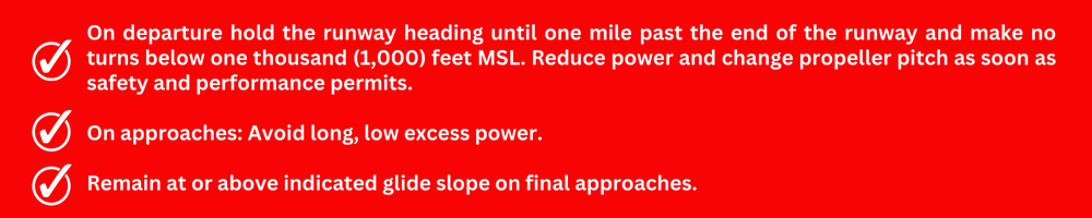
Pilots know best how to operate their aircraft so that they create the least amount of noise. These recommended procedures are not meant to interfere with safety, good judgment, FAA rules, or with techniques that good pilots know will help reduce ground noise from their aircraft. Jefferson County International Airport is adjacent to residential areas. Because of this, some residents are very sensitive to noise from aircraft. These recommended procedures are designed to reduce aircraft noise for the community while keeping visiting aircraft and their operators welcome. Pilots are requested to follow these procedures with respect for the local residents and for other pilots.
Low Flying Aircraft or Noise Concerns: Seattle Flight Standards District Office 800-354-1940 Ext. 0
FAA INFORMATION
Effective February 6, 2014
Location
FAA Identifier: 0S9
Lat/Long:
48-03-13.7000N / 122-48-38.3000W
48-03.228333N / 122-48.638333W
48.0538056 / -122.8106389
(estimated)
Elevation: 110.1 ft. / 33.6 m (surveyed)
Variation: 16E (2015)
From city: 4 miles SW of PORT TOWNSEND, WA
Time zone: UTC -8 (UTC -7 during Daylight Saving Time)
Zip code: 98368
Airport Operations
Airport use: Open to the public
Activation date: 01/1939
Sectional chart: SEATTLE
Control tower: no
ARTCC: SEATTLE CENTER
FSS: SEATTLE FLIGHT SERVICE STATION
NOTAMs facility: SEA (NOTAM-D service available)
Attendance: 0900-1800
Pattern altitude: 1000.1 ft. MSL
Wind indicator: lighted
Segmented circle: yes
Lights: ACTVT MIRL RY 09/27 – CTAF.
Beacon: white-green (lighted land airport). Operates sunset to sunrise.
International operations: international airport of entry
Airport Communications
CTAF: 123.0
AWOS: 119.025 MHz, phone: (360) 379-1199
WHIDBEY APPROACH: 118.2
WHIDBEY DEPARTURE: 118.2
Nearby radio navigation aids
VOR radial/distance | VOR name | Freq | Var
CVVr178/12.0 | PENN COVE | VOR/DME | 117.20 | 19E
PAEr271/22.9 | PAINE VOR/DME | 110.60 | 20E
NDB name | Hdg/Dist | Freq | Var | ID
LOPEZ ISLAND | 149/25.9 | 356 | 21E | OPZ | — .–. –..
FRIDAY HARBOR | 146/28.8 | 284 | 17E | FHR | ..-. …. .-.
SKAGIT/BAY VIEW | 196/29.4 | 240 | 16E | BVS | -… …- …
KITSAP | 340/33.8 | 206 | 16E | PWT | .–. .– –
CARNEY | 342/38.6 | 274 | 20E | CAN | -.-. .- -.
Airport Services
Fuel available: 100LL
100LL AVAILABLE 24 HRS WITH CREDIT CARD. NO CASH SALES.
Parking: hangars and tiedowns
Airframe service: MAJOR
Powerplant service: MAJOR
Bottled oxygen: NONE
Bulk oxygen: NONE
Runway Information
Runway 9/27
Dimensions: 3000 x 75 ft. / 914 x 23 m
Surface: asphalt, in good condition
Weight bearing capacity: Single wheel: 12.5
Runway edge lights: medium intensity
Runway 9
Latitude: 48-03.17027N
Longitude: 122-48.28087W
Traffic Pattern: Right
Markings: Basic, in good condition
Visual Slope Indicator: 2-light PAPI on right (4.00° glide path)
Runway End Identifier Lights: Yes (activate 123.0)
Obstructions: 101 ft. tree, 2186 ft. from runway, 191 ft. left of centerline, 21:1 slope to clear
Runway 27
Latitude: 48-03.28610N
Longitude: 122-48.99615W
Traffic Pattern: Left
Markings: Basic, in good condition
Visual Slope Indicator: 2-light PAPI on left (4.00° glide path)
Runway End Identifier Lights: Yes (activate 123.0)
Obstructions: 348 ft. hill, 9547 ft. from runway, 26:1 slope to clear